Solutions for logistics
WEB based applications for logistics
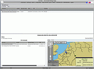
Routing algorithm for Inland Waterway navigation
Periskal has developed an own module for Route Calculation of Inland and Coastal Waterways in Europe. The module allows you to calculate travel distances and travel time on all Class I and higher waterways in Europe. At the same time all legal data like max allowed and maximum possible dimensions, max allowed draft and speed are given.
Coverage, all waterways within these limits
North: Inland waterways in Poland
South: the Canal de Sete and Rhone
West: the North Sea, River Seine upon Le Havre, The Westerschelde in Flushing, The Eemshaven at the Eems, Bremerhafen at the Weser, Cuxhaven at the Elbe
East: Danube Mouth, various branches including Bystroe in Ukraine, St. Georghe, Sulina Canal and the Black Sea Canal in Rumania. Also Bug and Dnipr in Ukraine are covered.
and also these waterways with less detail :
Inland Waterways in Russia between Baltic, Azov See and Caspic Sea
Inland Waters in the UK
Coastal Routes around Europe, North Sea, Atlantic Ocean, Mediteranean Sea, Black See and Azov Sea.
Properties
- All Class I waterways, rivers, canals and ports in Europe
- Mostly Class 0 waterways like in Holland
- Coastal Waters around Europe for Short Sea Traffic
- All legal dimensions of the waterways, bridges and locks like maximum allowed length, beam, draft, height and speed. Maximum possible dimensions.
- Including water gauge information - pegels and average current. Actual and average water levels are available
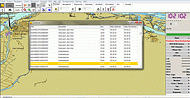
- Waterway network
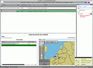
- Selection of navigation regime is possible
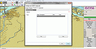
- Place of Departure and Arrival can be chosen based upon selection windows by country
- Average speed of vessel can be set
- Output : travel distance, travel time, max allowed dimensions including draft and lowest object on route, maximum possible dimensions
- Optional selection of coastal routes and average water level
Purpose
- Automatic prediction of ETA's of vessels at the terminals
- Automatic checking / validating ETA's on terminals
- Terminal planning
- Optional high end route planning can assist Fleet operators in choosing the optimal vessel, choosing optimal speed and Fuel reduction
- Cost calculation and optimal choice of Modality
- Promotion of Inland Shipping
- Promotion of Short Sea Traffic
XML WEB service for logistics
The same properties as described in the previous Web section are available through an XML web service which offers the possibility to retrieve data via a machine readable interface.
All the outputs given by the Route Calculation module such as:
- Travel distance and time
- Maximum dimensions, draft and speed allowed
- Maximum possible dimensions
- Forecast of the position of a vessel on the waterway network
- Optimal Route determination for multiple terminal loading/unloading
Solutions for logistics: Promotools
Logistic tools for Inland Navigation
Periskal has developed an own module for Route Calculation of Inland Waterways in Europe. The module allows you to calculate travel distances and travel time on all Class I and higher waterways in Europe. At the same time all legal data like max allowed dimensions, max allowed draft and speed are given. Also maximum possible dimensions are given.
The module is available as a web portal or is available as a web service for third party applications. The interface description is available on request. The module is able to forecast the position of a vessel on the waterway network and at the terminals and can assist logistic and terminal operators in the daily work. A user right management is possible so vessels and terminals can see only the information for them.
The Logistic Tool is available in a special (HTML -5 web based) version for Inland Navigation Promotion Agencies in order to show the possibilities of using transport over inland waters. The application can be run on PC's and smartphones/tablets. (Android and IoS)
Poject references: Logistics
RISING: Research project in the 7th Framework, DG TREN EU Execution 2009-2012
One of the main objectives of the RISING project is to exploit existing RIS services and data for logistic purposes. The project takes care of a better integration of Inland Waterway Transport into the logistics chain. It deals with planning processes (e.g. route planning, vessel and barge scheduling, voyage planning, fleet optimisation) as well as monitoring processes (e.g. ETA updates, tracking & tracing, SCEM).
Periskal was responsible for the development of a logistic web portal.
![]() For further information see also: www.rising.eu
For further information see also: www.rising.eu

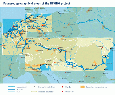
The geographical areas of the RISING project cover the following 3 selected European geographical waterway corridors:
1.Rhine-Scheldt
2.Danube
3.German waterway network (Weser/Elbe)
DVC: Dynamic traffic information service container transport
(Dynamische Verkeersinformatiedienst Containervervoer)
The usage of the fairway network can be improved by a better information flow and by improving the actual trip information of individual vessels. In this framework Connekt has launched, on behalf of Rijkswaterstaat, a price contest named ‘Dynamic traffic information service container transport’ (Dutch: DVC ‘Dynamische Verkeersinformatiedienst Containervervoer’).
One of its purposes is to increase the attractiveness of container transport in inland shipping thanks to efficient real-time information. In this way container transport via inland waterways can be increased. A consortium of RappTrans NL, Periskal and Adapticon has won the tender. The project mainly deals with a dynamic traffic information service which provides information to shippers, terminal operators and skippers.